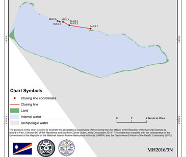
The Republic of the Marshall Islands has reached a major milestone in ocean resource management and international relations following the submission of their completed maritime boundary legislation to the United Nations on 22 April 2016. This legislation includes more than 450 pages of geographical coordinates, treaty agreements, and a total of 25 charts which will officially declare the baselines and the outer limits of all of its maritime zones under the national jurisdiction of the Marshall Islands. More information available here.